Cape Cod Rail Trail
 Riders and runners on the Brewster section of the Rail Trail - courtesy Justin Neviackas | |
| Vital Statistics | |
|---|---|
| Town | Multi-town |
| Administered By | Massachusetts Department of Conservation and Recreation |
| Where | Dennis, Harwich, Chatham, Brewster, Orleans, Eastham, Wellfleet. Trailheads and parking spots are available at many spots along the trail |
| Distance | 22.25 miles one way, Chatham extension is 7.3 miles one way |
| Surface | Paved asphalt |
| Last Visited | October 2008 |
| Ratings | |
| Overall | Easy |
| Walking | Excellent |
| Running | Excellent |
| Biking | Excellent. Many road crossings and heavy pedestrian traffic sometimes make for slow going but perfect for the leisurely rider. |
| Hiking | Fair |
About The Trail
Built on the railroad right of way originally owned by the Pennsylvania Central Railroad but maintained and operated by the Cape Cod Central Railroad Company. The railroad which was completed in the early 1880’s was primarily used by tourists from New York and Boston. The building of the bridges over the Cape Cod Canal in the 1960’s led to a quick decline in the popularity of rail service to Cape Cod and the railroad line east of Dennis fell into disrepair. The Massachusetts Department of Environmental Management (now the Massachusetts Department of Conservation and Recreation) purchased the right of way in 1978 and began planning the construction of a pedestrian and bicycling trail. In 1983, the main trail section from Dennis to Eastham was completed, the trail was officially opened for business in 1985, and an extension to South Wellfleet was added in 1994. In 2002, bridges over Route 6 were added in Orleans and Harwich and large sections of the trail were resurfaced. In 2006, the spur connecting Harwich and Chatham was officially opened for business and a $2 million renovation project marking the 20th anniversary of the rail trail moved into high gear.
As one would expect from an old railway bed, the Rail Trail is on the whole flat and straight. It slices through all of the towns of the Lower Cape and provides a convenient way to visit the downtown areas without much effort or mucking about in traffic. While it’s not as bad as the stop lights in a city, be prepared for many road crossings, especially in the more developed areas of the Cape. Enjoy the many conservation lands, ponds, cranberry bogs, wetlands and other areas that the trail passes through.
Getting There
Free parking is available at a number of stops along the route: Route 134 in S. Dennis, Bells Neck Road in Harwich, Headwaters Drive in Harwich, Route 124 in Brewster, Route 137 in Brewster, Nickerson State Park in Brewster, Salty Ridge Road in Orleans, Orleans Center, Salt Pond Visitors Center in Eastham and Lecount Hollow Road in Wellfleet. Restroom facilities are available in Dennis, Wellfleet, Orleans, and Nickerson State Park.
Maps
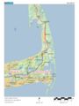
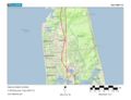
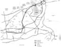
Full map - Source: Geof Newton
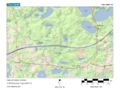
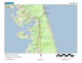
Dennis/Harwich Detail - Source: Geof Newton
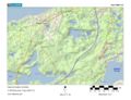
Harwich/Brewster Detail - Source: Geof Newton
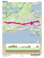
Orleans/Eastham Detail - Source: Geof Newton
Eastham Detail - Source: Geof Newton
Wellfleet Detail - Source: Geof Newton
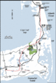
Harwich/Chatham Extension - Source: Geof Newton
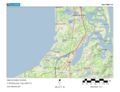
Full map - Source: Mass DCR
Dennis/Harwich/Brewster - Source: Mass DCR
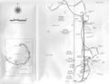
Orleans/Eastham/Wellfleet - Source: Mass DCR
- Ccrt.pdf
Full PDF Map (updated) - Source: Mass DCR


