Difference between revisions of "Punkhorn Parklands"
Jump to navigation
Jump to search
(→Maps) |
|||
| (4 intermediate revisions by the same user not shown) | |||
| Line 1: | Line 1: | ||
| − | |||
| − | |||
| − | |||
| − | |||
| − | |||
| − | |||
| − | |||
| − | |||
{{Stub}} | {{Stub}} | ||
| Line 29: | Line 21: | ||
==Maps== | ==Maps== | ||
| − | + | <gallery> | |
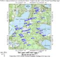
Image:punkhorn-boot.jpg|Source:Mass GIS and Town of Brewster | Image:punkhorn-boot.jpg|Source:Mass GIS and Town of Brewster | ||
Image:punkhorn-calf.jpg|Source:Mass GIS and Town of Brewster | Image:punkhorn-calf.jpg|Source:Mass GIS and Town of Brewster | ||
| Line 35: | Line 27: | ||
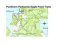
Image:punkhorn-1.jpg|Source:Cape Cod Trails | Image:punkhorn-1.jpg|Source:Cape Cod Trails | ||
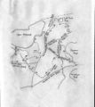
Image:punkhorn-topo.jpg|Source: Cape Cod Trails | Image:punkhorn-topo.jpg|Source: Cape Cod Trails | ||
| − | + | Image:punkhorn_parklands_northern_section_trail_map.jpg|Source: Town of Brewster | |
| + | </gallery> | ||
Latest revision as of 16:56, 1 August 2013
This article is a stub. You can grow the CCAC Wiki by expanding it.
| Vital Statistics | |
|---|---|
| Town | Brewster |
| Ratings | |
About The Trail
Getting There
Maps

Source:Mass GIS and Town of Brewster

Source:Mass GIS and Town of Brewster
Source:Mass GIS and Town of Brewster
Source:Cape Cod Trails
Source: Cape Cod Trails
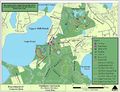
Source: Town of Brewster


