Difference between revisions of "Punkhorn Parklands"
Jump to navigation
Jump to search
(New page: ==Details== '''Where:''' '''Distance:''' '''Trail Rating:''' '''Surface:''' '''Walking:''' '''Running:''' '''Biking:''' '''Hiking:''' ==About The Trail== ==Getting There== ...) |
|||
| Line 22: | Line 22: | ||
==Maps== | ==Maps== | ||
| − | + | <gallery> | |
| − | + | Image:punkhorn-boot.jpg|Source:Mass GIS and Town of Brewster | |
| + | Image:punkhorn-calf.jpg|Source:Mass GIS and Town of Brewster | ||
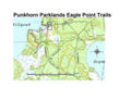
| + | Image:punkhorn-eagle.jpg|Source:Mass GIS and Town of Brewster | ||
| + | Image:punkhorn-1.jpg|Source:Cape Cod Trails | ||
| + | Image:punkhorn-topo.jpg|Source: Cape Cod Trails | ||
| + | </gallery> | ||
[[Category:Trails]] | [[Category:Trails]] | ||
Revision as of 09:18, 18 September 2008
Contents
Details
Where:
Distance:
Trail Rating:
Surface:
Walking:
Running:
Biking:
Hiking:
About The Trail
Getting There
Maps

Source:Mass GIS and Town of Brewster

Source:Mass GIS and Town of Brewster
Source:Mass GIS and Town of Brewster
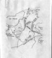
Source:Cape Cod Trails
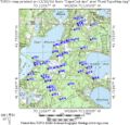
Source: Cape Cod Trails


